|
|
|
Limitations of CQ/X |
|
As
explained in the Introduction
the primary users of this software are expected to be mobile QSO
party operators. For this reason the initial focus has been on those
features that are likely to be useful in that environment. This leads
naturally to the following two limitations which will be addressed
eventually but at the present time are somewhat low priority.
SO2R SupportSome of the infrastructure is in place for supporting SO2R but in its current version the program must be considered to support only single radio operation. I'm not aware of any operators in state QSO parties using SO2R but of course in the other HF contests this is essential so as CQ/X expands to support these other contests the implementation of this capability will move up in priority. Networked OperationsA great deal of the infrastructure, including a server module for managing communications between the clients, is in place for supporting networked PCs running CQ/X clients but due to unfinished work in the error recovery area the current networked version of the program must be considered to be a beta version. W5ZL, KU5B, and I have successfully used a beta version of CQ/X in a network environment in the 2008 OK QP with good results. In the other HF contests networked operation is very common so as CQ/X expands to support these other contests the implementation of this capability will move up in priority.The
following factors might be considered
limitations but
are, for the most part, outside the control of CQ/X. County Changeover AccuracyIt's important to realize that several factors enter into the degree to which the county changeover, as detected by CQ/X, matches the county line markers. These factors include:
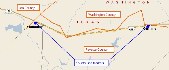
Each of these factors will influence the answer to the question: "As I pass a county line marker going 70 mph will the program change counties immediately before, after, or right at the marker? And if not right at the marker how far before or after?"; As they say on the internet "Your mileage may vary", but my experience has been that the changeover often occurs within 50 ft of the marker and that the worse case I have observed is about 440 yards (quarter mile) when going 70 mph.The normal update rate at which CQ/X performs the county detection calculation is 10 seconds. A vehicle going 70mph will travel about .20 mile in 10 seconds. In an attempt to minimize this effect the program has the capability of automatically adjusting its update rate as the boundary approaches. Since most GPS devices update at a 2 second rate this would indicate the smallest level of uncertainty one could hope for at 70 mph is about 70 yards assuming that the DOT and USGS are in exact agreement. Of course this ability to automatically update the rate as the vehicle appraoches the boundary requires that the user has provided the program with the latitude and longitude of the anticipated crossover point. Pathological County LinesOne should also be aware of other cases that might be considered pathological. As an example, look at the following section of US 290 between Houston and Austin where a county line criss-crosses the highway several times within only a few miles. This is a screen shot from Streets and Trips and the USGS data replicates this behavior. Click here to explore this example interactively using Google Maps with the USGS data as an overlay.
However, the TX DOT apparently decided to economize on county line markers and placed only two markers (Washington-Fayette at Carmine and Fayette-Lee near Ledbetter) in a stretch of road where, strictly speaking, there should have been six. So there are occassions wherein CQ/X will be (correctly) changing counties where no markers are present to indicate that a change is required. I'm also aware of a rural road (FM1486) north of Houston that travels along the Montgomery-Grimes county line for about a mile. In this case there could be at least a mile of uncertaintly and either delay or anticipation of the county line crossing. Think of all the roads with names like "County Line Road" and you can see there is a good possibility you will find yourself on one of these pathological cases at some point. Here's an example of an interstate (I-64) that travels along and very near to a county line in Indiana. There are, of course, many others like this. For the above reasons, before taking off on a trip with CQ/X, it pays to review your trip on a mapping program that shows county lines in order to be aware of any pathological cases that might exist along your planned route. Copyright: C.W. Sanders, NO5W Last Updated: 15-August-2010 |