|
|
|
Operating Without a GPS |
|
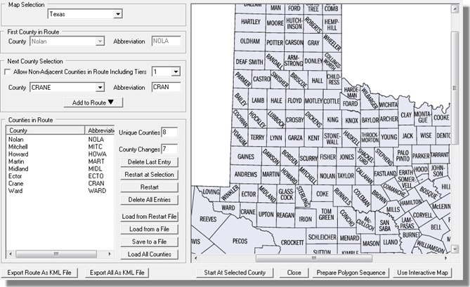
CQ/X can be operated with several levels of planning from virtually no planning to detailed planning including development of county line crossing locations, miles across each county, timing analysis, etc. If no GPS is to be used the best approach is to develop a list of counties sequenced in the order in which they are to be visited. The selection beforehand of the planned sequence of counties serves to improve the efficiency of the county changeover. CQ/X provides a tool for performing the pre-contest selection of the county sequence. This tool is accessed using the menu item QP Tools | Plan Route which activates the following dialog.
In this dialog a first county is selected, and the next county is selected from a combo box that shows all the counties adjacent to the previously selected county, etc. This process is repeated as necessary until all of the counties on the planned route have been specified including counties each time they are to be encountered on the route.
During operation the user changes the county by performing the key strokes Alt+Q (to get to the QP Tools menu) and then using the cursor (up/down arrow) keys to activate the Next County menu item -- or a function key can be assigned this task. At this point all county-dependent messages are automatically changed as are the logged county and the duping parameters. To move backward through the sequence the user can type Alt+Q and then the cursor keys to activate the Previous County menu item -- or a function key can be assigned this task. If for some reason a county outside of the planned sequence needs to be chosen the user can do so by typing a #-sign in the QSO Entry window and selecting the county from a drop down selection box.
Since the map used in this dialog is only an outline map it is important to check the developed sequence to make sure that there exist roads that will enable the counties to be traversed in the order specified.. The button labeled Prepare Polygon Sequence provides a means of developing a sequence of files defining the boundaries of the counties so that they can be overlaid onto a mapping program such as Streets and Trips to facilitate the plan of the roads to be traveled. Another button is provided for exporting the counties on the route as a KML file for posting on the web using Google maps. Several examples of these can be viewed from the Route Plans page. Copyright: C.W. Sanders, NO5W Last Updated: 26-April-2020 |